Temperatura, pioggia, sole.
Febbraio in Vietnam è in media un mese abbastanza caldo, con una temperatura media di 21,7 gradi. Nella capitale, Hanoi, la temperatura media è di 18,6 °C.
Le precipitazioni sono abbastanza rare, dato che ammontano in media a 26 millimetri, distribuiti in 7 giorni.
La temperatura del mare è in media di circa 24 °C. Dunque, il mare è abbastanza caldo per fare il bagno.
Il sole brilla in media per circa 5,5 ore.
Il giorno, dall'alba al tramonto, dura in media per circa 11,5 ore.
Temperature medie
Nella mappa seguente possiamo vedere le temperature medie, minime e massime, in Vietnam, nel mese di febbraio, in una selezione di località.
Mappa di: febbraio
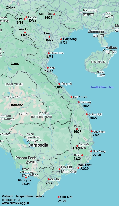 Vietnam - temperature medie di febbraio.
Medie climatiche del mese - Febbraio
La tabella seguente mostra le medie climatiche nel mese di febbraio in Vietnam. Vietnam - Dati climatici a Febbraio| Città | Temperatura
(°C) | Precipit. | Temp.
mare (°C) |
|---|
| Min | Max | Media | mm | giorni | |
|---|
Buon Ma Thuot
(535 m.) | 18 | 30 | 23,9 | 5 | 1 | |
|---|
| Can Tho | 23 | 31 | 27,0 | 5 | 1 | |
|---|
Cao Bang
(200 m.) | 14 | 21 | 17,3 | 25 | 9 | |
|---|
| Con Son | 24 | 29 | 26,6 | 15 | 1 | 26 |
|---|
Da Lat
(1.500 m.) | 12 | 24 | 17,8 | 10 | 2 | |
|---|
| Da Nang | 20 | 26 | 23,2 | 25 | 6 | 24 |
|---|
| Dong Hoi | 18 | 23 | 20,7 | 40 | 11 | 23 |
|---|
| Haiphong | 16 | 21 | 18,6 | 30 | 13 | 21 |
|---|
| Hanoi | 16 | 22 | 18,6 | 20 | 12 | |
|---|
| Ho Chi Minh | 23 | 33 | 28,0 | 5 | 1 | 25 |
|---|
| Hue | 18 | 25 | 21,7 | 65 | 12 | 23 |
|---|
| Lao Cai | 15 | 22 | 18,6 | 35 | 9 | |
|---|
| Nha Trang | 22 | 28 | 25,0 | 15 | 4 | 26 |
|---|
| Phan Thiet | 23 | 30 | 26,3 | 0 | 0 | 26 |
|---|
| Phu Quoc | 24 | 31 | 27,8 | 30 | 4 | 28 |
|---|
Pleiku
(750 m.) | 16 | 28 | 22,0 | 5 | 1 | |
|---|
| Quang Ngai | 20 | 27 | 23,5 | 45 | 8 | |
|---|
| Quy Nhon | 22 | 28 | 24,9 | 30 | 6 | 25 |
|---|
Sa Pa
(1.500 m.) | 8 | 14 | 10,8 | 80 | 16 | |
|---|
Son La
(600 m.) | 12 | 23 | 17,9 | 25 | 4 | |
|---|
| Thanh Hoa | 16 | 20 | 18,3 | 20 | 12 | 22 |
|---|
| Vinh | 17 | 22 | 19,2 | 40 | 14 | 22 |
|---|
Media
Febbraio | 18,0 | 25,4 | 21,7 | 25,8 | 6,7 | 24,2 |
|---|
Quando possibile, i dati fanno riferimento al periodo climatico standard definito dall’Organizzazione Meteorologica Mondiale (OMM), cioè il trentennio 1991-2020.
Scegli un altro mese. Vedi il clima in Vietnam nel mese di:
Vedi il clima -
Vietnam